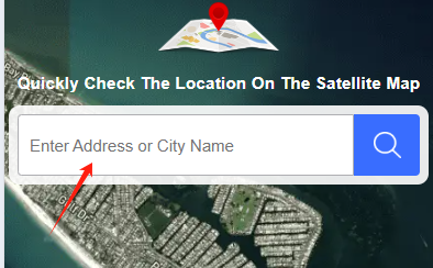
Explore Homes with Interactive Maps

Discover properties like never before with high-resolution satellite maps and 3D views. See exact locations, explore the surrounding environment, and plan routes to your future home with ease.

Property Location Visualization

Embed high-resolution satellite maps in the property listings or detail pages to show the exact location of each home within the community or city, allowing users to clearly understand the surrounding environment, transportation, greenery, and amenities.

Route Planning and Transportation Information

With the satellite map’s route feature, users can enter their current location to see the best route to their target home, including driving, walking, or biking directions.

3D Map Experience

If the map supports 3D functionality, users can virtually explore the community layout and home exteriors on the website, experiencing the property from both a macro and micro perspective.

Printed Directions Map

Route Found!

Once your route is ready, you can view the step-by-step directions and explore the path to your destination easily.

Use the Website

Start exploring Earth3DMaps instantly! Here's how:

Open Widget Icon

Open the Website

Go to earth3dmaps.com in your browser to start exploring interactive 3D Earth views instantly.

Open Widget Icon

Search HD Satellite Maps

Enter a place in the search box and press Enter to load a high-resolution satellite view of that location.

Close Widget Icon

Get Directions

Click "Directions," enter your start and destination, then choose Drive/Walk/Bike to display the route.